COPPER
La Gran Cruzada
Andes Mineral Exploration´s (AMEx) exploration activities are focussed on the Puna Plateau in the Central Andes and extending along the border between northern Chile (Region II) and the Salta Province of NW Argentina. The Puna belt
contains significant copper and gold mineralization including the world‐class Taca Taca porphyry Cu‐Au deposit as well as the Arizaro and Lindero iron‐oxide Cu‐Au projects. The Taca Taca Cu‐Au mine is situated about 230km to the WNW of the
city of Salta, near the Chilean border.
| Geology | Cu-Au porphyry and epithermal style alteration |
| Location | Westernmost part of the Province of Salta, Los Andes Department, NW Argentina, 450 km west of the City of Salta |
| Discovered | Andes Mineral Exploration S.A. |
| Elevation | Between 4,100 m and 5,100 m |
| Exploration to date |
Desktop Studies: spectral analysis and target-modeling. Confirmation of mineralization at surface from float chip samples. |
| Next Phase (Oct. 2021) |
Reconnaissance exploration program Target Area I complimented with field mapping. |
| Ownership | 100% by AMEx |
| Major Projects in the Puna Atacama Plateau |
Lindero Au porphyry, mine commissioned and in production (Fortuna Silver) 70 km SW; Taca Taca Cu-Mo deposit (First Quantum) 70 km due West; Escondida Cu Mine (BHP JV) 75 km to the WNW in Chile |
La Cruzada regional geology
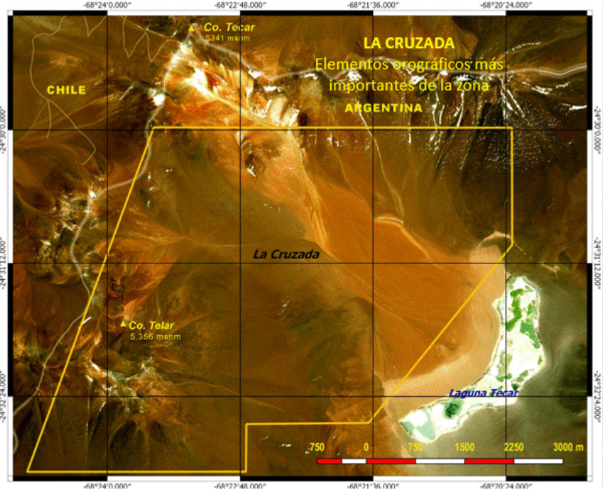
The La Gran Cruzada Cu-Au prospect (“La Cruzada” or the “Project”) is situated in the high Andes in the SW part of the Salta Province of Argentina, in the Department of the Andes, immediately adjacent to the border with Region II in Chile. The highest peaks are the Socompa volcano to the NE and the Llullaillaco to the SW with elevations of more than 6000 m MSL (Fig. 2). The region belongs to the Miocene metallogenic belt of the Andes (Sillitoe, 2010). The Salta province is well endowed with copper and gold mineralization including the Taca Taca deposit to the east and, Rio Grande to the south and the Arizaro project and the Lindero mine to the southeast of the La Gran Cruzada Project.
The geology of this region is dominated by Upper Miocene to Pliocene andesitic stratovolcanoes and dacite domes that are partly covered by Pliocene ignimbrites and pyroclastic sequences (Camus and Castelli, 2021). The geological basement consists of Mesozoic and Paleozoic meta-sediment units that are locally intruded by diorite and granodiorite stocks of the Taca Taca and Chuculaqui Formations.
There are also numerous hypabyssal porphyritic felsic to intermediate intrusions of the Llullaillaco intrusive complex and, more rarely, Mesozoic syenite stocks. These porphyritic intrusions are hornblende- and biotite‐phyric and have high-K calc-alkaline compositions (Kay et al., 1999; Camus and Castelli, 2021). Large parts of the region are concealed by Pliocene ignimbrites as well as andesitic to dacitic volcaniclastic sequences from the Quaternary Socompa volcano.
The structural setting of the region is dominated by regional deep-seated NE- trending basement structures of Paleozoic age that are locally intersected by NW‐trending high‐angle Triassic and N‐S oriented Tertiary faults (Camus and Castelli, 2021). During the Tertiary, compressive tectonics dominated the geological evolution of the area and is documented in N-S trending and west- dipping reverse faults. During intermittent phases of relaxation N-trending normal faults were formed and are best preserved in the higher parts of the region. The location of stratovolcanoes such as Villalobos and Socompa which dominate the morphology of the region appears to be structurally controlled by N‐S trending faults (Camus and Castelli, 2021). The area contains abundant ancient pirquinero workings and gold and copper showings.
La Cruzada prospect geology
The La Gran Cruzada Project comprises 6.568 hectares and it is situated about 15 km to the SW of Socompa volcano that dominates the topography of the area. The prospect geology is dominated by Tertiary andesitic to dacitic volcaniclastic
sequences that are covered by ignimbrites in places. The rocks are overprinted by widespread and texturally destructive hydrothermal alteration, especially along NW- or NE-trending structures or at their intersections. Vuggy textures of
andesite units are common (Figs 4 and 5). Airborne spectral analysis reveals that the hydrothermal alteration assemblages mainly consist of pyrophyllite as well as Ca‐ and K-alunite phases. The center of the prospect contains a large zone of
clay-sericite alteration, measuring about 3.5 km across.
Although part of the clay alteration could be attributed to late-stage volcanic activity and de-gassing of Socompa volcano, the formation of significant alunite-pyrophyllite alteration requires much higher temperatures, revealing a increased
potential for a concealed porphyry Cu system at La Cruzada.
HYDROTHERMAL ALTERATION AND MINERALIZATION
An algorithm-based remote sensing interpretation of multi- and hyperspectral data from the central part of the La Gran Cruzada property reveals advanced argillic alteration assemblages including pyrophyllite as well as K‐ and Na‐alunite,
respectively. The documented hydrothermal alteration assemblage is interpreted as a lithocap overlying concealed porphyry Cu centers and locally emplaced by outcropping high‐sulfidation epithermal‐style hydothermal breccias containing up to 4.1 g/t Au. The geological setting and alteration mineralogy favourably compare with the world‐class Taca-Taca porphyry Cu‐Au deposit in the vicinity.
Three initial reconnaissance rock chip sampling programmes were conducted, and 38 rock samples were recovered and subsequently processed and assayed at MSALabs in San Juan, Argentina and Vancouver, Canada respectively.
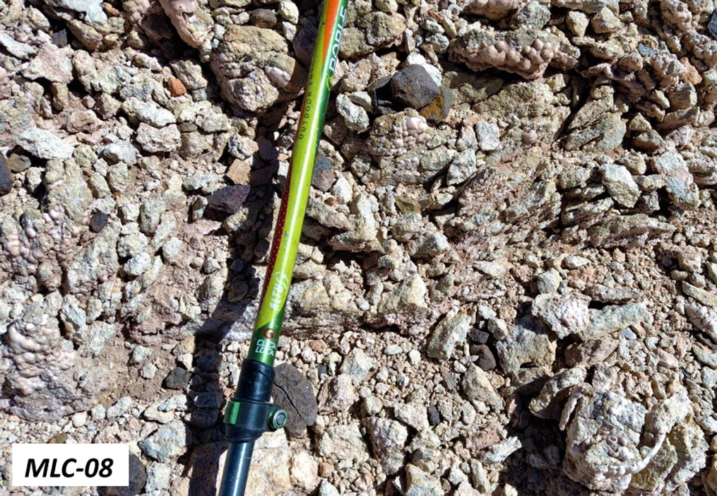
The Miocene andesites dominating the property are overprinted by advanced argillic alteration assemblages including Na‐alunite, K‐alunite and pyrophyllite as well as vuggy silica textures. Rock chip samples of oxidized hydrothermal breccias with strong advanced argillic alteration returned high Mo contents of up to 7g/t (Sample LC‐08B) and up to 4.1 g/t Au (Sample MLC‐030), respectively.
Comprising an oxidized and strongly argillic altered hydrothermal breccia containing large subangular clasts with quartz‐hematite stockwork veining is documented in Figure 8. Both hydrothermal breccias and their andesitic wall rocks are overprinted by intense and pervasive advanced argillic (both K‐ and Na‐alunite) alteration. The outcrop of sample MLC‐030 measures about 10m across and is located about 1000m to the west of the la Laguna Tecar.

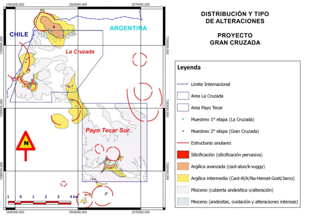
Outcrop map showing exposures of advanced argillic altered andesite units and reconnaissance rock chip sample locations (blue). Argillic alteration assemblages are outlined in yellow; advanced argillic alteration (Na‐alunite, K‐alunite, pyrophyllite) assemblages are shown in orange; intense silicification is illustrated in red, respectively. Note the zoned lithocap alteration zone in the northern part of the property which corresponds to a large magnetic doughnut anomaly discussed below.

Rock chip sample of oxidized hydrothermal breccia overprinted by strong advanced argillic alteration (Sample LC‐08B; 7.0 g/t Mo).
EXPLORATION POTENTIAL FOR CONCEALED PORPHYRY Cu‐Au DEPOSITS
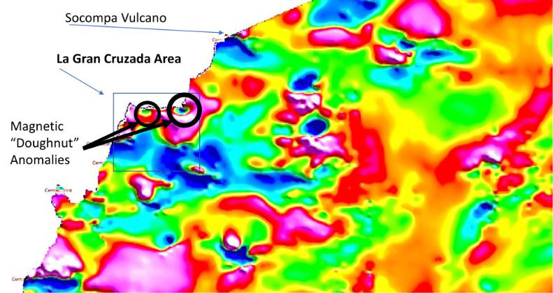
The La Cruzada property includes two large magnetic doughnut anomalies, each measuring several hundred meters across (Fig. 1). Note that the western magnetic anomaly overlaps with a zoned lithocap alteration zone outcropping at surface. Their spatial association with advanced argillic alteration assemblages, vuggy silica textures and gold‐mineralized hydrothermal breccias containing clasts with quartz‐hematite stockwork veining makes them significant exploration targets for high‐sulfidation epithermal gold mineralization and underlying concealed porphyry Cu systems.
Importantly, concealed porphyry Cu systems either form magnetic “bullseye” or “doughnut” anomalies in magnetic surveys due to their hydrothermal biotite-magnetite (potassic) alteration assemblages. However, during the waning and cooling stages of the hydrothermal system, cooler late-stage fluids can overprint the mineralization and its associated potassic alteration assemblage. This may lead to subsequent oxidation (i.e., martitization) of hydrothermal magnetite to hematite. This process can lead to the de‐magnetization of the original magnetic bullseye signature in its center and producing a “doughnut-shaped” or “torus-like” magnetic anomaly Kwan and Müller, 2020).
A systematic hyperspectral traversing program, a detailed magnetic survey and alteration mapping of the La Cruzada lithocap is planned to find structures with hydrothermal alterations and/or mineralization controlling the hydrothermal system. The La Cruzada project can be quickly advanced to the reconnaissance drilling stage.
Material
Lithocap, polymetallic mineralization and magnetic “doughnut”-shaped anomalies make La Cruzada a prime porphyry and HSE exploration target.


